The harbour front, wharf by wharf
Newport turned toward its harbour long before the summer houses. Walk the wharves off Thames Street, look across to Goat Island's light and watch the boats come and go.
Before Newport was a summer resort it was a port, and for a time in the eighteenth century one of the busiest in British North America. Its merchants traded with the West Indies, Africa and Europe. Rum distilled here was carried to West Africa and exchanged for enslaved people, who were taken across the Atlantic, and Newport merchants were among the most deeply involved in the American slave trade. The wealth that built many of the colonial houses on The Point and around Washington Square came through these wharves.
The harbour today is mainly for pleasure boats, but the shape of the old port is still there: the long wharves running out from Thames Street, the sheltered water behind Goat Island, and the harbour mouth opening west toward the bay.
The Revolution ended that prosperity. British troops occupied Newport from 1776 to 1779, many residents fled, and the town's trade never regained its colonial scale. That long pause is one reason so many eighteenth-century buildings survived: for decades there was little money to replace them.
Thames Street and the line of wharves
Thames Street runs along the harbour from the Point at the north end to the lower town in the south, roughly following the old shoreline. The wharves run out from it at right angles, each with its own name and history, and between them are basins full of boats.
The best way to understand the waterfront is to walk out to the end of a wharf, look back at the town, and then walk the street to the next one. You see the spires and roofs of the colonial town rising behind the waterfront, the Colony House on Washington Square, and the steeple of Trinity Church. Several wharves have public walkways along their edges; others are private marinas. Where a gate or sign says private, respect it.
Many of the buildings along the street date from the nineteenth century, when the waterfront was a working place of chandlers, sail lofts, warehouses and fish dealers. A long decline followed, and much of the lower waterfront was rebuilt from the 1960s onward, when a new road was cut along the shore and the wharves turned toward visitors.
Bowen's Wharf and the old warehouses
Bowen's Wharf, off the middle of Thames Street, keeps some of the old waterfront buildings: plain, timber-framed warehouses with steep roofs, built to store goods coming off ships. Several now hold businesses, but their bones are the same.
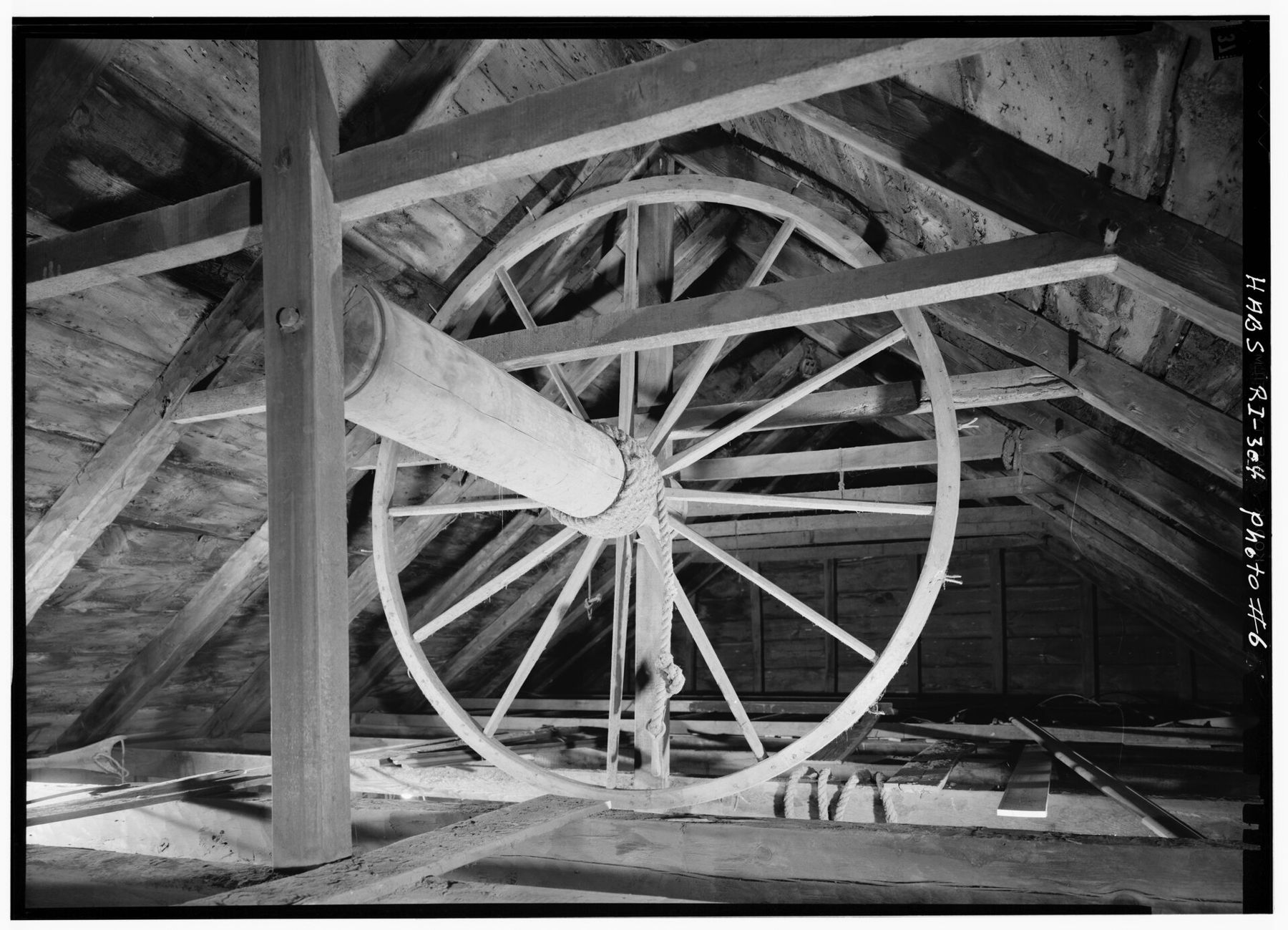
In the attics of some of these buildings, wooden windlasses remain: great spoked wheels on a horizontal axle, used to haul cargo up through holes in the floors below by rope. A federal survey of historic buildings measured and drew several of the Bowen's Wharf structures, recording the framing of the roofs and the windlass gear in detail.
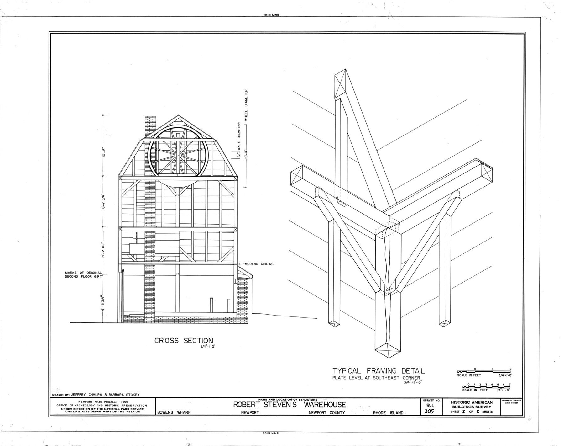
When you walk the wharf, look up at the gable ends. The hoist doors near the peaks, where goods were lifted in from carts and boats, are still visible on some of the buildings.
The wharf itself follows the line it has followed since the eighteenth century, though its paving and edges have been relaid many times.
Also under flag FFort Adams: walls, tunnels and the harbour mouth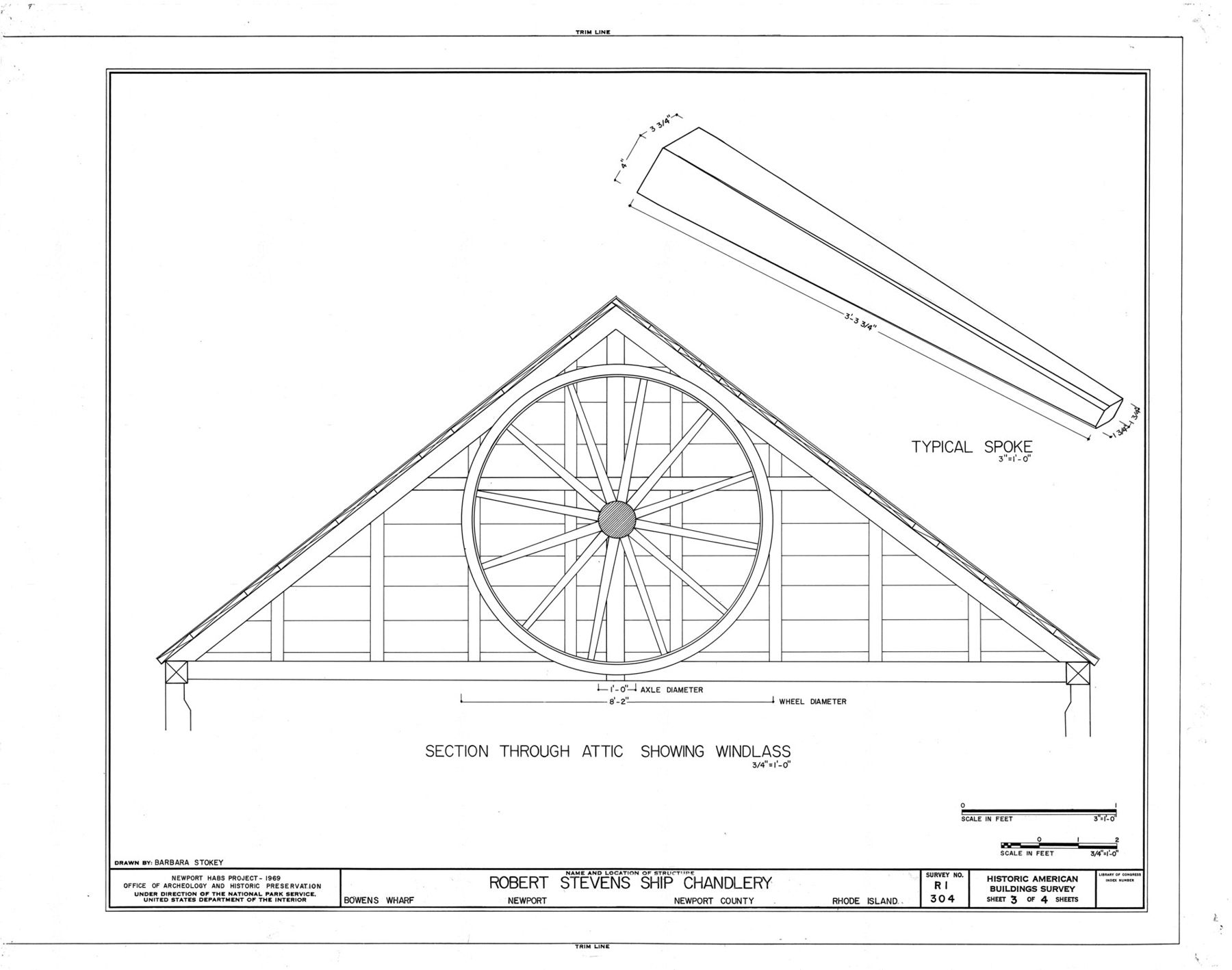
The light on Goat Island
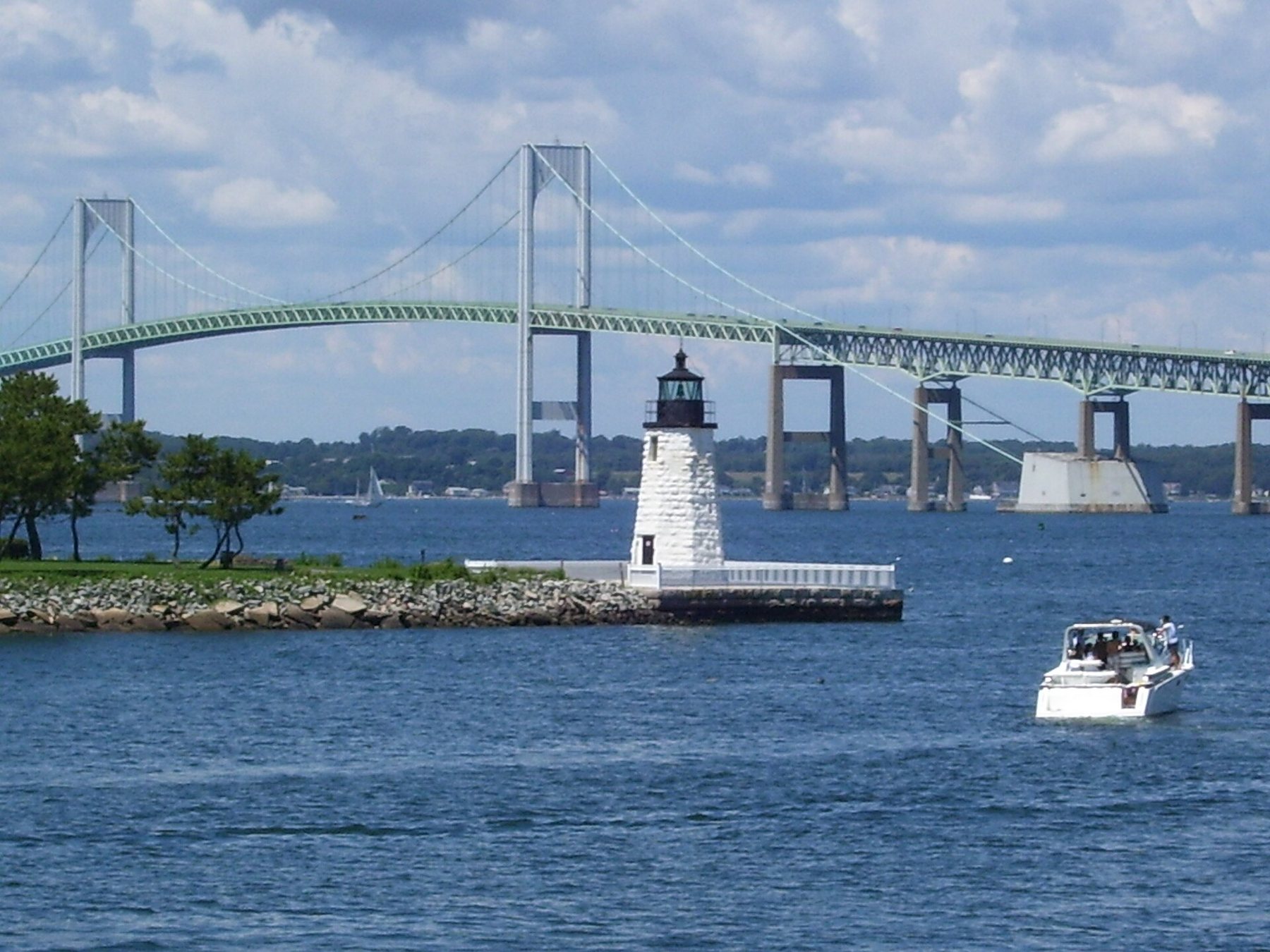
Across the harbour lies Goat Island, joined to the town by a causeway. The island was used for fortifications and later by the Navy, which built torpedoes there for many years. At its northern tip, at the end of a stone breakwater, stands Newport Harbor Light, a short granite tower with a lantern on top, marking the entrance to the inner harbour.
The causeway to Goat Island leaves from the waterfront near the Point. Walking across takes a few minutes, and from the causeway you look down into the moorings on both sides.
From the Goat Island side, looking back across the moorings, you get the whole waterfront in one view.
The breakwater has been open to walkers at times, though the light itself is not; check access before you go. From the Goat Island side, looking back across the moorings, you get the whole waterfront in one view. Beyond the light, the Newport Bridge crosses the bay to Jamestown, and on a summer evening the sun drops behind it. The nearby lights are the subject of Lights across the bay.
Moorings and the sailing season
The harbour is crowded with moorings from late spring to autumn. Small launches run between the docks and the moored boats, and the channel down the middle stays busy with sailboats, motorboats, fishing boats and, on some summer days, very large yachts. Newport was the home of the America's Cup races for much of the twentieth century, and the sailing culture runs deep.
Fishing boats and lobster boats still work out of Newport, and you see them moving among the yachts early in the morning and late in the day.
The sailing season builds through June, peaks in July and August, and continues into September and October, when the light is softer and the wind steadier. Regattas, boat shows and race starts fill the harbour on particular weekends; the date moves from one year to the next, so look it up before you plan around it. In winter many boats are hauled out, the moorings thin, and the harbour is quiet and gray.
Winter has its own appeal. The water is often flat and steel-coloured, sea ducks feed in the harbour, and the wharves are quiet enough that you hear the halyards slapping on the remaining masts.
Where to watch the boats
The ends of the public wharves are the simplest places to sit and watch. Goat Island and its breakwater give a good view of the boats coming in and out of the inner harbour. For the wider harbour mouth and the bay, go out to Fort Adams, on the western side of the harbour, where the lawns look straight across the entrance.
Late afternoon is the best time. The southwest breeze is at its strongest, the boats are coming back to their moorings, and the low sun lights the sails from behind. Once the breeze drops in the evening, the water flattens out and the reflections of the town lights come up in the basins.
In the evening the town end of the harbour fills with people walking the wharves, and the boats in the basins light up one by one. It is a good time to walk the waterfront from end to end, from the Point down to the lower harbour, and back up through the streets of the old town.
Several boats offer harbour tours and sails in season; their schedules and departures change, and it is worth checking before you go. Ferries also run across the bay in summer, which is one of the best ways to see the harbour from the water.